
Millions of Californians were under flood alerts and warnings of excessive rainfall on Feb. 5, 2024, as a powerful atmospheric river sat over Southern California. Los Angeles saw one of its wettest days on record with over 4 inches of rain on Feb. 4, communities reported widespread flooding, and debris and mudslides shut down sections of highways and roads into Malibu.
It was the latest in a series of atmospheric rivers to bring extreme rainfall to the West Coast. While these storms are dreaded for the damage they can cause, they are also essential to the region’s water supply, particularly in California, as Qian Cao, a hydrologist at the University of California, San Diego, explains.
What are atmospheric rivers?
An atmospheric river is a narrow corridor or filament of concentrated water vapor transported in the atmosphere. It’s like a river in the sky that can be 1,000 miles long. On average, atmospheric rivers have about twice the regular flow of the Amazon River.
When atmospheric rivers run up against mountains or run into local atmospheric dynamics and are forced to ascend, the moisture they carry cools and condenses, so they can produce intense rainfall or snowfall.
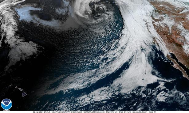
A satellite view of atmospheric rivers.
Atmospheric rivers occur all over the world, most commonly in the mid-latitudes. They form when large-scale weather patterns align to create narrow channels, or filaments, of intense moisture transport. These start over warm water, typically tropical oceans, and are guided toward the coast by low-level jet streams ahead of cold fronts of extratropical cyclones.
Along the U.S. West Coast, the Pacific Ocean serves as the reservoir of moisture for the storm, and the mountain ranges act as barriers, which is why the western sides of the coastal ranges and Sierra Nevada see so much rain and snow.
Why are back-to-back atmospheric rivers a high flood risk?
Consecutive atmospheric rivers, known as AR families, can cause significant flooding.
The first heavy downpours saturate the ground. As consecutive storms arrive, their precipitation falls on soil that can’t absorb more water. That contributes to more runoff. Rivers and streams fill up. In the meantime, there may be snowmelt due to warm temperatures, further adding to the runoff and flood risk.
California experienced a historic run of nine consecutive atmospheric rivers in the span of three weeks in December 2022 and January 2023. The storms helped bring most reservoirs back to historical averages in 2023 after several drought years, but they also produced damaging floods and debris flows.

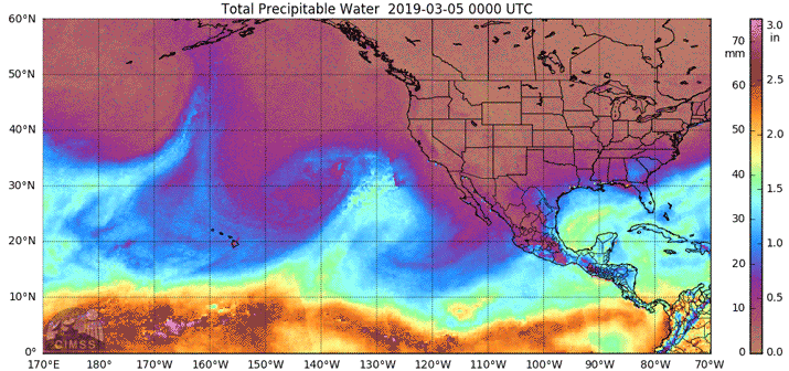
Atmospheric rivers forming over the tropical Pacific Ocean head for the U.S. West Coast. NOAA
The cause of AR families is an active area of research. Compared with single atmospheric river events, AR families tend to be associated with lower atmospheric pressure heights across the North Pacific, higher pressure heights over the subtropics, a stronger and more zonally elongated jet stream and warmer tropical air temperatures.
Large-scale weather patterns and climate phenomena such as the Madden-Julian Oscillation, or MJO, also play an important role in the generation of AR families. An active MJO shift occurred during the early 2023 events, tilting the odds toward increased atmospheric river activity over California.
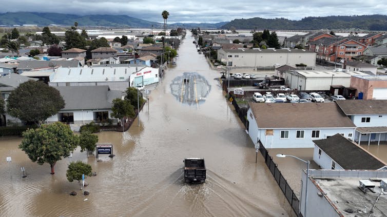
An aerial view shows a flooded neighborhood in the community of Pajaro in central California on March 11, 2023, after a series of atmospheric rivers. Josh Edelson/AFP via Getty Images
A recent study by scientists at Stanford and the University of Florida found that storms within AR families cause three to four times more economic damage when the storms arrive back to back than they would have caused by themselves.
How important are atmospheric rivers to the West Coast’s water supply?
I’m a research hydrologist, so I focus on hydrological impacts of atmospheric rivers. Although they can lead to flood hazards, atmospheric rivers are also essential to the Western water supply. Atmospheric rivers have been responsible for ending more than a third of the region’s major droughts, including the severe California drought of 2012-16.
Atmospheric rivers provide an average of 30% to 50% of the West Coast’s annual precipitation.
They also contribute to the snowpack, which provides a significant portion of California’s year-round water supply.
In an average year, one to two extreme atmospheric rivers with snow will be the dominant contributors to the snowpack in the Sierra Nevada. Together, atmospheric rivers will contribute about 30% to 40% of an average season’s total snow accumulation there.
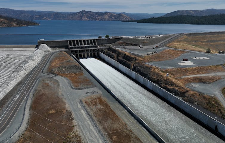
After several winter storms brought record snowfall to California’s Sierra Nevada in early 2023, Lake Oroville, California’s second-largest reservoir, was at 100% capacity. The previous year, much of the state had faced water restrictions. Justin Sullivan/Getty Images
That’s why my colleagues at the Center for Western Weather and Water Extremes at the Scripps Institution of Oceanography, part of the University of California, San Diego, work on improving atmospheric river forecasts and predictions. Water managers need to be able to regulate reservoirs and figure out how much water they can save for the dry season while still leaving room in the reservoirs to manage flood risk from future storms.
How is global warming affecting atmospheric rivers?
Warmer air can hold more moisture. As global temperatures rise in the future, we can expect more intense atmospheric rivers, leading to an increase in heavy and extreme precipitation events.
My research also shows that more atmospheric rivers are likely to occur concurrently during already wet conditions. So, the chance of extreme flooding also increases. Another study, by scientists from the University of Washington, suggests that there will be a seasonal shift to more atmospheric rivers earlier in the rainy season.
There will likely also be more year-to-year variability in the total annual precipitation, particularly in California, as a study by my colleagues at the Center for Western Weather and Water Extremes projects.
This article was update Feb. 5, 2024, with flooding and mudslides in California.![]()
Qian Cao, Hydrologist, Center for Western Weather and Water Extremes, University of California, San Diego
This article is republished from The Conversation under a Creative Commons license. Read the original article.
Spread the word